Wednesday, September 17, 2025

Yellowstone on the Move: Elk, Bison, and the Paths They Take


Most people think of Yellowstone as a vast, protected wilderness. But for the park’s animals, it is only one piece of the puzzle. Wildlife migrations extend well beyond its boundaries, driven by ancient instincts and modern pressures. Elk travel more than 100 miles each year, bison push into surrounding valleys, and predators follow prey across invisible lines. Human barriers complicate these routes, while climate change alters them entirely. This documentary captures the beauty, danger, and resilience of Yellowstone’s migrations, showing why corridors outside the park are just as important as the landscapes within it.

Exploring why animals leave Yellowstone reveals an overlooked reality: the hiden journeys of wildlife and the truths behind their constant movement. From predator-prey dynamics to climate change and human obstacles, every factor shapes the way animals move through the Greater Yellowstone Ecosystem. What emerges is a powerful message—these journeys are not just local phenomena but vital threads in the broader fabric of ecological resilience.

In this article, we’ll unpack the science of wildlife migration, the challenges animals face outside the park, and why their movements matter to ecosystems and people alike.

The Myth of Containment

Yellowstone covers nearly 3,500 square miles—about the size of Rhode Island and Delaware combined—making it one of the largest protected areas in the United States. Yet even this vastness is not enough to sustain many species year-round. Animals need more than scenic meadows or geothermal basins. They need food, water, shelter, and safety—resources that shift with the seasons and climate.

The invisible reality is that Yellowstone functions less like an island and more like a hub within a sprawling ecological network. For example, biologists have tracked elk migrating up to 150 miles from their summer ranges in the park to wintering grounds outside its boundaries. Bison, too, move seasonally, with some herds traveling 50–70 miles in search of forage.

This simple truth challenges the romantic notion of Yellowstone as a closed, self-sufficient sanctuary. Animals leave because survival demands it.

Migration: Following Food and Water

Elk are among Yellowstone’s most iconic travelers. The park is home to 10 major elk herds totaling around 30,000–40,000 animals. In summer, they graze the lush high meadows within the park. But as snow deepens and forage disappears, herds instinctively move down valleys and across rivers into surrounding lands, sometimes venturing into private ranches and towns.

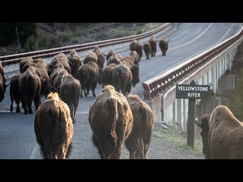
Bison, numbering about 5,900 in 2023, engage in massive migrations. In winter, they push northward toward Gardiner Basin or westward into the Madison Valley. These routes, etched into memory over generations, allow them to follow the rhythm of snow and grass availability.

Without these movements, starvation would loom. Migration is not simply an option—it is a biological necessity.

Predators and the Drama of Movement

Predators play a dramatic role in shaping these migrations. Wolves, reintroduced to Yellowstone in 1995 after a 70-year absence, have profoundly influenced elk behavior. The park now supports about 125 wolves across 13 packs. Rather than lingering in open valleys where wolves can corner them, elk move more frequently, scattering across varied terrain.

Grizzly bears, whose Greater Yellowstone population has rebounded from fewer than 150 individuals in the 1970s to over 1,000 today, also influence prey movement. During spring, when bears emerge from hibernation, elk calves become vulnerable targets. This predation pressure encourages elk to calve in areas beyond park boundaries, where bear densities may be lower.

Predator-prey dynamics remind us that migration is not only about food and water but also about safety and survival strategies shaped by evolutionary pressures.

Human Boundaries and Conflicts

While Yellowstone’s animals recognize no borders, humans impose them. Beyond the park’s edge lie highways, fences, ranches, and expanding communities. These structures fragment migration routes, turning once-fluid journeys into dangerous obstacles.

Highways are particularly deadly. Across the Greater Yellowstone Ecosystem, vehicle collisions kill an estimated 5,000–10,000 large animals every year, including elk, deer, and bison. Fences, designed for livestock, can block wild herds and even cause fatal entanglements.

Ranching operations also bring conflict. Concerns about brucellosis, a disease carried by bison that can infect cattle, have led to aggressive management actions. Between 2000 and 2020, more than 12,000 Yellowstone bison were either shipped to slaughter or shot after leaving park boundaries.

These conflicts show the stark contrast between animals’ instinctive needs and the artificial barriers humans create.

Climate Change: A Shifting Map

Perhaps the most unsettling force shaping Yellowstone’s wildlife movements is climate change. Winters in the region are now about two weeks shorter than they were 50 years ago, with reduced snowpack and earlier spring melt. These shifts are redrawing the map of migration.

Elk and bison encounter unpredictable snow conditions that affect forage availability. Rivers fed by melting snow peak earlier in the year, disrupting aquatic systems that many species depend on. Wildfires, which burned more than 1.2 million acres in the Greater Yellowstone Ecosystem since 1988, further fragment habitats and force animals to seek refuge in unfamiliar areas.

These changes compound existing pressures from human development. What was once a reliable seasonal journey is becoming a gamble with survival.

Wildlife Corridors: The Bridges Beyond Borders

The true lifelines for Yellowstone’s animals are wildlife corridors—stretches of habitat that allow species to move safely between seasonal ranges. These can be river valleys, mountain passes, or undeveloped lands that connect ecosystems across vast distances.

Research shows that the Greater Yellowstone Ecosystem contains at least 11 major migration corridors, many of which extend well beyond the park. For instance, GPS tracking has revealed mule deer traveling more than 240 miles between Wyoming’s Red Desert and Yellowstone—the longest known migration for the species in North America.

Conservationists are working tirelessly to protect and restore these corridors. Wildlife overpasses in Wyoming and Montana have reduced roadkill by up to 90% in some areas. Land easements and collaborative agreements with ranchers are helping to keep critical pathways open.

Without these connections, Yellowstone would become an ecological cage, and species survival would falter.

The Human Dimension: Why It Matters

At first glance, the journeys of Yellowstone’s animals may seem like local concerns, relevant only to the park’s immediate surroundings. But their significance extends far beyond.

  1. Ecological Health – Migration maintains healthy ecosystems. Elk and bison moving across landscapes redistribute nutrients; in fact, studies show migratory ungulates can transport nutrients tens of miles through their waste, enriching soils and influencing plant communities.

  2. Cultural Value – Indigenous communities, including the Shoshone, Bannock, and Crow, have long followed these migrations for subsistence and ceremony. Protecting corridors honors this deep cultural heritage.

  3. Economic Impact – Yellowstone attracts over 4 million visitors annually, generating nearly $600 million in tourism revenue for surrounding communities. Much of that appeal comes from the chance to witness roaming wildlife. Without migration, these spectacles would diminish.

  4. Global Lessons – Yellowstone’s challenges mirror those faced worldwide. From elephants in Africa (whose ranges have shrunk by over 50% in the last century) to caribou in the Arctic (with some herds declining by more than 90%), migratory species everywhere confront habitat loss, climate pressures, and human conflicts. Learning from Yellowstone helps us address these global crises.

Toward a Shared Future

Yellowstone’s animals remind us that life is movement, connection, and resilience. Borders may be human inventions, but nature knows no such limits.

The survival of elk, bison, bears, and wolves depends on our willingness to see beyond lines on a map. Protecting wildlife corridors, addressing climate change, and reducing human-wildlife conflict are not acts of charity but investments in a shared future.

Every journey out of Yellowstone tells a story of adaptation, challenge, and hope. And in following these journeys, we discover truths not only about animals but about ourselves—our responsibility, our interdependence, and our capacity to shape a world where both people and wildlife can thrive.

Final Thoughts

The hidden truths behind why animals leave Yellowstone reveal more than migration patterns. They expose the fragility of ecosystems, the tension between human progress and natural instinct, and the resilience of creatures that refuse to be confined.

Yellowstone is not an isolated wonder but a node in a global web of life. Protecting its wandering animals is not just about preserving wildlife—it’s about safeguarding the health of our planet and honoring the timeless journeys that sustain it.

Their paths cross ours, even if we don’t always see them. And their survival, ultimately, is bound to our own.

Monday, September 15, 2025

The Science of Permafrost Thaw and Its Global Consequences


To understand one of the biggest climate risks of our time, you have to look down—into the frozen soils of the Arctic that are thawing faster than expected.

The Science Behind Permafrost Thaw and Why It Matters

Permafrost is not just frozen dirt—it is a massive, ancient reservoir of carbon, ice, and organic matter. Found across Alaska, Canada, Greenland, Siberia, and northern Scandinavia, permafrost covers nearly 13 million square kilometers, or about 24% of the land in the Northern Hemisphere.

Much of this permafrost has remained frozen since the last Ice Age. Locked inside it are vast amounts of undecomposed plant and animal material—frozen in time for thousands of years. Scientists estimate that permafrost contains 1,500–1,700 billion metric tons of carbon, which is almost twice the carbon currently present in Earth’s atmosphere.

The problem arises when permafrost thaws. As the ice melts, microbes awaken and begin decomposing the organic matter, releasing greenhouse gases like carbon dioxide and methane. Methane is especially potent: over a 20-year period, it traps 84 times more heat than CO₂. This means that thawing permafrost has the potential to release greenhouse gases at a scale that rivals human emissions, setting off a dangerous chain reaction.

How Arctic Communities Are Living on the Frontlines of Change

While the carbon threat is global, the human cost is intensely local. Across the Arctic, communities are witnessing their landscapes—and lives—transformed.

In Alaska, permafrost thaw is undermining homes, schools, and roads. The U.S. Army Corps of Engineers has identified more than 30 communities in Alaska at imminent risk of collapse or relocation due to thaw, erosion, and rising seas. In Shishmaref, residents voted to relocate their entire village as the ground sinks beneath them.

In Siberia, the consequences are equally severe. In 2020, thawing permafrost caused the collapse of a fuel tank near Norilsk, spilling 21,000 tons of diesel into rivers and wetlands. It was one of the worst environmental disasters in the Russian Arctic and cost more than $2 billion in cleanup efforts.

For Indigenous peoples, permafrost thaw is also a cultural crisis. Traditional hunting, fishing, and herding routes depend on frozen landscapes that are now unstable. A recent study found that by 2050, up to 70% of Arctic infrastructure—including Indigenous settlements, pipelines, and roads—will be at high risk of damage if warming continues unchecked.

The Hidden Feedback Loop Accelerating Climate Change

Permafrost thaw is one of the most dangerous climate feedback loops. Here’s how it works:

  1. Global warming raises Arctic temperatures (the Arctic is warming at 4 times the global average).

  2. Permafrost thaws, releasing CO₂ and methane.

  3. These greenhouse gases accelerate global warming.

  4. More warming causes deeper, faster permafrost thaw.

This feedback loop is already measurable. A 2021 study showed that Arctic permafrost is releasing around 0.6 billion tons of carbon annually—comparable to the yearly emissions of an industrialized nation like Germany. Worse still, this process is not accounted for in many global climate models, meaning the risks may be underestimated.

By 2100, under high-emissions scenarios, permafrost could release 150–200 billion tons of carbon dioxide-equivalent gases. That’s the same as adding three to four years of today’s global fossil fuel emissions—without any possibility of reversing the process once it begins.

What’s at Stake for Ecosystems, Economies, and Our Future

Ecosystems in Transition

Permafrost thaw reshapes entire landscapes. As ice within the ground melts, the land can slump dramatically, forming sinkholes and wetlands. These changes alter ecosystems: boreal forests collapse into marshy terrain, lakes drain suddenly, and coastlines erode. Species such as reindeer, caribou, and migratory birds lose critical habitats. Meanwhile, warming wetlands produce even more methane, compounding the problem.

Emerging Health Risks

Thawing permafrost may also reawaken ancient pathogens. In 2016, thawed reindeer carcasses infected with anthrax triggered an outbreak in Siberia, killing a child and hospitalizing dozens. Researchers warn that other microbes—some tens of thousands of years old—could emerge, creating new public health risks.

Economic Costs

The financial burden is staggering. In Alaska alone, thaw-related infrastructure damage could cost $5.5 billion by 2100. Across the circumpolar north, total costs of repairing and replacing damaged buildings, roads, and pipelines could reach tens of billions of dollars by mid-century. Globally, the economic damages from permafrost carbon release have been projected at $70 trillion by 2300 if emissions remain high.

A Global Climate Threat

What makes permafrost especially alarming is its ability to undermine international climate goals. The Paris Agreement aims to limit global warming to below 2°C, ideally 1.5°C. But if permafrost emissions are not included in models, humanity may overshoot those targets even if we succeed in cutting fossil fuel emissions. In other words, permafrost could push us past critical tipping points.

A Call to Action

Permafrost thaw may feel like a faraway issue, but its consequences ripple across the entire planet. Stopping it entirely may not be possible, but slowing its progression is within reach.

  • Cutting emissions: The single most effective strategy is to drastically reduce fossil fuel emissions. Every fraction of a degree matters in slowing thaw.

  • Supporting Arctic communities: Investments in resilient infrastructure, community relocation, and cultural preservation are urgent. Indigenous knowledge must be centered in adaptation strategies.

  • Boosting research: More monitoring of permafrost is essential. Currently, much of the Arctic remains unstudied, leaving major gaps in understanding how quickly thaw is occurring.

  • Global awareness: Permafrost must be recognized as a global climate issue, not just a regional concern. Policymakers need to integrate permafrost feedbacks into climate models and international agreements.

The thawing of the frozen North is a stark reminder of the interconnectedness of our planet. What lies hidden beneath Arctic soil could shape the future of life everywhere. The question is whether humanity will act decisively—or let the silent crisis beneath our feet decide for us.

Sunday, September 14, 2025

Pressure and Darkness: Survival in the Deep Ocean


Beneath the calm waves lies a world as alien as the surface of distant planets. The hadal zone, with its relentless pressure and eternal darkness, harbors creatures that seem to belong to another universe.


The Mysterious World of Deep Ocean Trenches

  • Average ocean depth: ~3,688 meters (12,100 feet)

  • Mariana Trench (Challenger Deep): ~10,984 meters (36,037 feet)

  • If Mount Everest stood inside the Mariana Trench, its peak would still be buried under 2,135 meters (7,000 feet) of water.

  • Around 33 deep-sea trenches are known, covering just 2% of the seafloor.

These trenches form in subduction zones, where one tectonic plate plunges beneath another, recycling Earth’s crust and triggering powerful earthquakes and volcanic activity. They are not just scars on the seafloor but gateways into Earth’s extreme frontier—shaping oceans, continents, and even climate.

Life in the Abyss: Extraordinary Deep-Sea Creatures

Despite the hostile environment, life in the trenches thrives in mind-bending ways:

  • Over 90% of deep-sea species remain undiscovered.

  • Bioluminescence: About 75% of deep-sea animals glow, turning the darkness into a living light show.

  • Anglerfish: Dwell at 2,000–2,500 meters (6,600–8,200 feet), using glowing lures powered by bacteria to attract prey.

  • Fangtooth fish: Survive depths up to 5,000 meters (16,400 feet), armed with teeth proportionally larger than any other fish.

  • Giant amphipods: Grow up to 30 cm (1 foot)—ten times the size of their shallow-water cousins.

  • Microbes: Thrive even at 10,900 meters (35,760 feet), enduring pressures that would crush a submarine.

These organisms demonstrate nature’s ingenuity, evolving survival strategies for life in crushing darkness, scarce food supplies, and near-freezing waters.

Survival at the Limits

The trenches test the very definition of survival:

  • Pressure: At Challenger Deep, 1,086 bars (15,750 psi)—equivalent to 50 jumbo jets weighing down on a single human body.

  • Temperature: Most waters hover between 1–4 °C (34–39 °F), while hydrothermal vents can spike to 400 °C (750 °F).

  • Light: Sunlight disappears entirely at around 200 meters (656 feet).

  • Oxygen: Low levels force slow metabolisms and unique adaptations.

In this world, survival strategies border on the alien—glowing lures, gelatinous bodies, and chemical-based metabolisms.

Geological Secrets Written in the Trenches

The deepest trenches don’t just harbor life—they archive Earth’s history:

  • Subduction rates: Plates sink at up to 10 cm (4 inches) per year.

  • Earthquakes: ~90% of global quakes strike near subduction trenches.

  • Sediment cores: Preserve millions of years of climate history.

  • Carbon storage: Trenches act as natural carbon traps, regulating Earth’s atmosphere.

Studying these deep scars reveals not only how the planet functions today but also how it has evolved over millions of years.

The Last Great Frontier

Despite decades of effort, the hadal zone is still largely a blank map:

  • 80% of the ocean remains unmapped.

  • Fewer than 30 people have descended to Challenger Deep—far fewer than the 600+ astronauts who have ventured into space.

  • Only 0.05% of the hadal zone has been biologically sampled.

  • In 2012, James Cameron’s solo dive reached 10,908 meters (35,787 feet), bringing back rare samples and images from the abyss.

Each new mission reveals creatures and processes as strange as anything imagined on distant planets.

Conclusion: Earth’s Hidden Frontier

The trenches may hold millions of undiscovered species and geological mysteries waiting to be decoded. They challenge our definition of habitability and remind us of life’s resilience under impossible conditions.

Every expedition into the abyss proves that the deep ocean is Earth’s final frontier—vast, mysterious, and still keeping its greatest secrets.

Summary: Secrets of the Deep

The deepest ocean trenches are among the most extreme environments on Earth—where crushing pressure, freezing cold, and total darkness collide. Yet life thrives, from glowing predators to microbes that defy physics. With most of the ocean still unexplored and countless species yet to be discovered, the trenches remain one of humanity’s last great mysteries. Each dive takes us closer to understanding not just the deep sea, but the story of our planet itself.

Saturday, September 13, 2025

What Tree Rings Tell Us About Past Weather and Future Climate


How do scientists know what the climate was like centuries—or even millennia—before satellites and weather stations existed? The answer often lies within trees. Each ring inside a trunk records not just age but also the environmental conditions of that year. This science, known as dendrochronology, allows researchers to reconstruct past weather and climate patterns with remarkable precision. As modern climate change accelerates, understanding how Earth’s climate behaved before industrialization provides crucial perspective. Tree rings are among the most reliable natural archives we have, linking ancient events to today’s environmental challenges.

Trees in temperate regions form one ring each year, and ring width and density vary with rainfall, temperature, and soil conditions. Wide rings indicate warm, wet years with favorable growth, while narrow rings reveal stressful years marked by drought or cold. Some species, like California’s bristlecone pines, live for nearly 5,000 years, offering one of the longest continuous records of climate history on Earth.

The field of dendrochronology began in the early 20th century with astronomer A.E. Douglass, who noticed links between tree growth and solar cycles. His research soon showed that tree rings also captured rainfall and temperature shifts, laying the foundation for modern climate reconstruction. Today, dendrochronology has expanded into a global database of over 4,000 tree-ring chronologies. The rings themselves form as trees grow: in spring, rapid growth produces lighter wood, while summer and fall growth is slower, creating darker, denser layers. This contrast produces the visible rings, which scientists analyze to build year-by-year weather records reaching back thousands of years, often with accuracy to the exact season.

Drought is one of the clearest signals preserved in tree rings. Narrow rings reveal years of water scarcity. Tree-ring studies in the American Southwest, for example, uncovered “megadroughts” lasting 20–40 years—far longer than anything in modern weather records—and one such drought contributed to the decline of the Ancestral Puebloans in the late 1200s. Similarly, unusually wet years leave their mark, as abundant rainfall creates wide growth bands and flood damage may scar the wood. In the Amazon Basin, tree rings have revealed flood cycles stretching back 400 years, providing insights into regional hydrology long before satellite monitoring. Volcanic eruptions also leave signatures: ash and aerosols block sunlight, cooling the planet and reducing growth, which shows up as narrow rings. The 1815 eruption of Mount Tambora, for instance, triggered the infamous “year without a summer,” and tree rings from North America and Europe confirm global temperature drops of up to 3°C and widespread crop failures.

By matching overlapping ring patterns from living trees, old beams, and fossilized wood—a process called crossdating—scientists create continuous climate timelines. Oak chronologies in Germany now extend back 12,000 years, making them among the longest in the world. Tree-ring data often align with turning points in human history: severe droughts in Central America coincided with the Maya collapse in the 9th century, while European records show colder conditions during the Little Ice Age (1300–1850), when average temperatures fell by 1–2°C, leading to poor harvests and social unrest.

Tree ring science separates natural climate swings from human-caused warming. Data show that the past few decades are the warmest in at least 1,200 years, underscoring how exceptional modern warming is. Reconstructions also inform water management and agriculture by revealing long-term drought cycles. A 2022 study, for example, showed that the 2000–2021 drought in the U.S. Southwest was the driest 22-year span in 1,200 years, affecting water supplies for over 40 million people in the Colorado River Basin. Beyond averages, rings capture individual heatwaves, frosts, or floods—data crucial for predicting how climate extremes may evolve under global warming.

Global collaboration has amplified dendrochronology’s impact. The International Tree-Ring Data Bank (ITRDB) stores more than 500,000 tree-ring measurements from across the globe, allowing scientists to trace worldwide impacts of volcanic eruptions, solar cycles, and El Niño. Preserved logs, archaeological timbers, and fossilized trees extend records beyond the lifespan of living species, pushing climate history back to the last Ice Age, roughly 20,000 years ago. However, dendrochronology works best in regions with clear seasonal growth. In tropical areas, where growth may be continuous, rings can be faint or absent, limiting reliability. Researchers are developing new techniques, such as stable isotope analysis, to fill these gaps.

Compared with past climate variability, today’s warming is faster and more extreme. Since 1850, global temperatures have risen by about 1.2°C, a pace unmatched in tree-ring records spanning thousands of years. Tree rings remind us that societies throughout history have been shaped—and sometimes toppled—by climate extremes. Studying these records helps us prepare for the shocks ahead, from megadroughts to super floods. Ultimately, tree rings are far more than natural curiosities: they are precise records of droughts, floods, volcanic winters, and long-term climate shifts. As we confront intensifying global warming, these ancient witnesses provide both context and warning, offering insights that can guide us toward a more resilient future.

Tuesday, September 9, 2025

Super Blood Moon: When Two Lunar Phenomena Collide


The Moon has always fascinated humanity. Sometimes it swells in size and brightness, illuminating the night sky like a cosmic spotlight. Other times, it darkens into a mysterious shade of red, as though bleeding across the heavens. These two events — the Supermoon and the Blood Moon — spark awe and curiosity every time they appear. But what’s really happening? Why does one shine so brightly while the other glows red?

Here’s a closer look at the cosmic mechanics behind these unforgettable lunar shows.

Supermoons: The Moon at Its Closest

What is a Supermoon?

A Supermoon occurs when the full Moon coincides with perigee, the point where the Moon is closest to Earth in its elliptical orbit. At perigee, the Moon is about 356,500 km away, compared to 406,700 km at apogee (its farthest point). That difference of roughly 50,000 km makes the Moon appear up to 14% larger and 30% brighter than when it’s farther away.

To put it in perspective: if you compared two coins, one a dime and the other a nickel, that’s roughly the visual difference between a normal full Moon and a Supermoon.

Why Does It Look Bigger on the Horizon?

The dramatic size when a Supermoon rises isn’t because of actual magnification. Instead, it’s due to the Moon Illusion. When seen near trees, buildings, or skylines, our brains interpret it as larger than when it’s high overhead.

Blood Moons: The Moon in Earth’s Shadow

What is a Blood Moon?

A Blood Moon happens during a total lunar eclipse, when Earth moves directly between the Sun and the Moon. Rather than disappearing, the Moon turns red or orange.

Why Red, Not Black?

The effect comes from Earth’s atmosphere. Sunlight bends around our planet, filtering out shorter wavelengths like blue and letting red and orange pass through. That reddish light bathes the Moon, creating the “blood red” look.

During an average century, there are about 85 total lunar eclipses, so Blood Moons are relatively rare compared to Supermoons.

Supermoon vs Blood Moon: Key Differences

  • Cause:

    • Supermoon → The Moon’s orbit brings it closer to Earth.

    • Blood Moon → Earth’s shadow covers the Moon during a total eclipse.

  • Appearance:

    • Supermoon → Brighter, up to 30% more light than usual.

    • Blood Moon → Dimmer, glowing red or copper.

  • Frequency:

    • Supermoon → 3 to 4 times per year.

    • Blood Moon → Roughly every 2 to 3 years.

  • Visibility:

    • Supermoon → Seen worldwide if skies are clear.

    • Blood Moon → Visible only on the night side of Earth during the eclipse.

When Supermoons and Blood Moons Overlap

Sometimes, a Supermoon coincides with a total lunar eclipse, producing a Super Blood Moon. These rare events happen once every decade or so. The last occurred in May 2021, and the next is expected in September 2033.

During these events, the Moon appears both larger and redder — an awe-inspiring combination that fuels myths and media buzz.

Cultural and Historical Meanings

Throughout history, these lunar events carried powerful symbolism.

  • Supermoons were linked to tides and emotions. They do raise tides slightly, producing what are known as perigean spring tides. These tides are 5–10 cm higher than average, enough to affect low-lying coastal areas.

  • Blood Moons were feared as omens. Ancient Mesopotamians believed they foretold danger for kings. Biblical texts reference the Moon turning to blood as a sign of apocalypse. Even today, the phrase “Blood Moon prophecy” often goes viral during eclipses.

The Science Behind the Spectacle

  • Elliptical Orbits: The Moon’s path varies due to gravitational pulls from Earth, the Sun, and other planets, creating perigee (close) and apogee (far).

  • Atmospheric Scattering: The same physics that make sunsets red give Blood Moons their color. Without Earth’s atmosphere, lunar eclipses would leave the Moon completely black.

  • Human Perception: Our minds exaggerate the size of the Moon near the horizon, making Supermoons feel even larger than they are.

How to See Them

  • Supermoons: Simply look up during the night of a perigee full Moon. Use binoculars or telescopes for stunning close-ups of lunar craters and maria.

  • Blood Moons: Best viewed in dark areas away from light pollution. Total lunar eclipses last several hours, with totality — the red phase — typically lasting 30 to 90 minutes.

Conclusion

Supermoons and Blood Moons are two of the most spectacular natural shows in our sky. One dazzles with brightness and size, while the other glows mysteriously red under Earth’s shadow. Together, they remind us of the delicate balance between Earth, Moon, and Sun.

So the next time you see a swollen silver disk or a crimson Moon, remember: you’re witnessing cosmic mechanics in action. The science makes them even more magical — proof that the night sky never runs out of wonders.

Shifting Magnetic Poles: The Hidden Threat to GPS, Aviation, and Smartphones


Are you ready to question everything you thought you knew about your GPS? 🌍✨ The North Pole isn’t as fixed as it seems—and its movement could be silently disrupting the technology we rely on every day. From your car’s navigation system to global aviation routes, Earth’s shifting magnetic field is a hidden force that could change the way we travel, communicate, and explore the world.

The Hidden Truth About the North Pole Shift

For centuries, navigators have relied on Earth’s magnetic field for direction. But here’s the secret: the magnetic North Pole is on the move.

  • In 1831, scientists first pinpointed its location on Canada’s Boothia Peninsula.

  • By 2000, the pole had already migrated over 600 miles (965 km).

  • Today, it’s racing toward Siberia at speeds of 34–40 miles per year (55–65 km)—almost four times faster than its 20th-century average.

This geomagnetic shift isn’t just trivia; it affects navigation systems, satellites, and even your smartphone’s compass.

Why Is the Magnetic Pole Moving?

Earth’s magnetic field is generated by liquid iron and nickel currents swirling in the outer core, 1,800 miles (2,900 km) beneath the surface. These movements produce a geomagnetic field that:

  • Extends tens of thousands of miles into space.

  • Protects Earth from solar radiation and cosmic rays.

  • Is constantly changing—weakening, strengthening, and shifting over time.

Right now, scientists report that Earth’s magnetic field has been weakening at a rate of ~5% per century, particularly in a region known as the South Atlantic Anomaly.

How Magnetic Shifts Affect GPS and Technology

You may wonder: “Doesn’t GPS rely on satellites, not magnets?” True—but magnetic field changes still play a role in global positioning accuracy.

Key Impacts:

  • Aviation Navigation: Runway designations must be updated regularly because they’re based on magnetic north. For instance, Tampa International Airport had to renumber two runways in 2011 to align with the pole’s drift.

  • Military & Shipping: Even a 1–2° compass error can equal several miles off course over long distances at sea or in the air.

  • Smartphones: Compass apps use both GPS and magnetometers. If magnetic data isn’t updated, users can experience 5–10 meters of directional error in everyday navigation.

  • Global Positioning Satellites: NASA and ESA estimate that solar storms amplified by magnetic field shifts could cause up to 10 meters of GPS error during peak activity.

True North vs. Magnetic North: Why It Matters

  • True North: Earth’s geographic axis of rotation—completely stable.

  • Magnetic North: Generated by the planet’s molten core—constantly shifting.

The gap between these two can exceed 1,000 miles (1,600 km) today. Without corrections, aviation and shipping systems could suffer serious navigation errors, especially at high latitudes near the Arctic.

Could the Pole Shift Lead to a Magnetic Reversal?

Magnetic reversals have happened before—about 183 times in the past 83 million years. The last full reversal, called the Brunhes–Matuyama reversal, occurred roughly 780,000 years ago.

  • During reversals, the magnetic field weakens by as much as 90%, leaving Earth more vulnerable to solar radiation.

  • Satellites, power grids, and navigation systems could all be disrupted.

  • Scientists estimate the field is currently weakening at ~10% per century, fueling speculation about whether a reversal may be underway.

What This Means for the Future of Navigation

The North Pole pole shift isn’t science fiction—it’s science fact. Governments and agencies like NOAA (U.S.) and the British Geological Survey release updates to the World Magnetic Model (WMM) every 5 years to keep navigation accurate. In 2019, an emergency update was issued ahead of schedule because the pole’s movement was so rapid.

Navigation Tips to Stay Ahead of the Shift

  • Update your devices: Smartphone GPS and mapping apps incorporate WMM updates to correct for magnetic drift.

  • Stay informed: Check resources from NOAA, ESA, or NASA for the latest magnetic field data.

  • Learn backup methods: Traditional compasses and celestial navigation can provide redundancy when GPS isn’t reliable.

  • Watch for aviation advisories: Pilots already receive updated runway headings and charts as the pole continues to shift.

Final Thoughts

The mystery of the shifting North Pole is more than just an interesting fact—it’s a growing challenge for global technology. From aviation navigation problems to smartphone GPS malfunctions, Earth’s magnetic pole movement is already affecting how we travel and communicate.

The next time you follow your GPS, remember: the ground beneath your feet—and the invisible magnetic shield around Earth—is always moving.

👉 Stay curious, stay updated, and don’t forget to share this with fellow science and tech enthusiasts!

Yellowstone on the Move: Elk, Bison, and the Paths They Take

  Most people think of Yellowstone as a vast, protected wilderness. But for the park’s animals, it is only one piece of the puzzle. Wildlif...